A map that reflects more than just the shape of the land—it tells the story of what it feels like to be there.
It’s more than an island—it’s a memory map for so many.
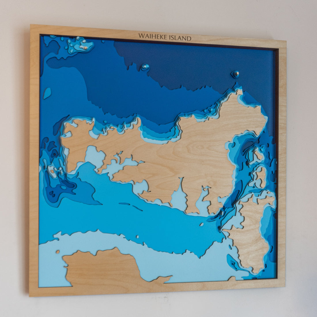
When we started designing our map of Waiheke Island, we knew we had to get it right.
Waiheke isn’t just a dot on the chart. It’s where families gather for summer swims, where locals know the best bay for scallops, where ferries carry city dwellers to salt-air weekends, and where sunsets linger longer than they should.
So when we sat down to translate its underwater contours into layered wood, we weren’t just thinking about bathymetry—we were thinking about emotion.
🌊 Why Contour Matters in Mapmaking
In every Tides Out Map, we use real hydrographic data to reflect the actual underwater topography of the location.
But there’s still an art to choosing the contour line—the shape and depth that becomes the visual heartbeat of the piece.
For Waiheke, we went with a contour that highlights:
-
The gentle shelved bays on the north side (perfect for anchoring and family swims)
-
The steeper drop-offs along the southern coastlines (familiar to local fishos and divers)
-
The wider expanse around Te Matuku Marine Reserve
-
And the delicate channels separating Waiheke from Motuihe, Rakino, and the mainland
It’s a contour that feels just like Waiheke: soft, spacious, welcoming—with a few deep secrets below the surface.
📏 Balancing Beauty & Accuracy
We test each map cut first in digital form, then in physical layers—because what works on a screen doesn’t always sing in wood.
For Waiheke, we found that going one contour deeper than our usual standard revealed stunning shapes around:
-
Man O’ War Bay
-
Palm Beach & Onetangi’s sweeping shallows
-
And the intricate edges of Surfdale and Blackpool
We wanted every curve of the coastline to feel true—not just to satellite data, but to how it feels to stand barefoot on the beach, looking out to sea.
🛠️ Handcrafted to Honour the Island
Every Waiheke map is:
-
Laser-cut from sustainable plywood
-
Hand-layered to show depth and flow
-
Customisable with names, boat references, or family messages
-
And framed with care, ready to hang in a bach, boat, or city home that misses the water
It’s one of our most popular New Zealand pieces, not because of hype—but because of heart.
💬 For the People Who Know Waiheke Best
Some of the custom messages we've engraved on Waiheke maps:
“Where we said yes.”
“Dad’s launch point, every summer.”
“The ferry was the start of everything.”
That’s the power of getting the contours right.
It’s not just a line—it’s a memory boundary.
🎁 Want to Customise Your Waiheke Story?
You can personalise your Waiheke Island map with:
-
A boat name
-
A date
-
A family bach name
-
Or even a GPS mark that means something only to you