Mapping the Ocean Floor: A Studio Day at Tides Out Maps
🌊 Turning Depth into Design
Every piece of ocean has a story—an ebb and flow shaped by time, tide, and topography. At Tides Out Maps, our mission is to capture that story, layer by layer, in art you can hang on your wall. But what does it actually take to map the ocean floor and turn it into a handcrafted piece?
Come behind the scenes with us for a studio day at Tides Out, where science meets creativity, and where every map begins with a deep dive into the contours of the sea.
🖥️ 9:00 AM – From Data to Depth
Our day starts not with a brush or chisel, but with bathymetric data—charts and models that show the depth of the ocean floor. We study:
-
Satellite bathymetry
-
Nautical navigation charts
-
Regional topographic overlays
We look for the natural shapes that define each region: submerged valleys, shelves, trenches, and shoals. These aren’t just lines on a screen—they’re the foundation of our maps’ storylines.
💡 Fun fact: Bathymetry is like topography, but underwater. It helps us visualise not just where the land ends—but what lies beyond.
✏️ 11:00 AM – Designing the Flow
Once we’ve analysed the depth layers, it’s time to refine them into flowing, visual forms. Our map artists:
-
Trace and simplify key bathymetric lines
-
Adjust spacing for visual clarity and balance
-
Preserve scientific accuracy while enhancing legibility
We often pause and ask: “What will this look like on someone’s wall?”
We want maps that are geographically honest but also visually beautiful—calming, clean, and full of movement.
🪵 1:00 PM – Into the Workshop
Next, the data becomes tangible. In our workshop, we:
-
Select premium wood sheets or archival-grade paper
-
Laser-cut each layer to reflect changes in ocean depth
-
Sand, clean, and hand-finish every piece
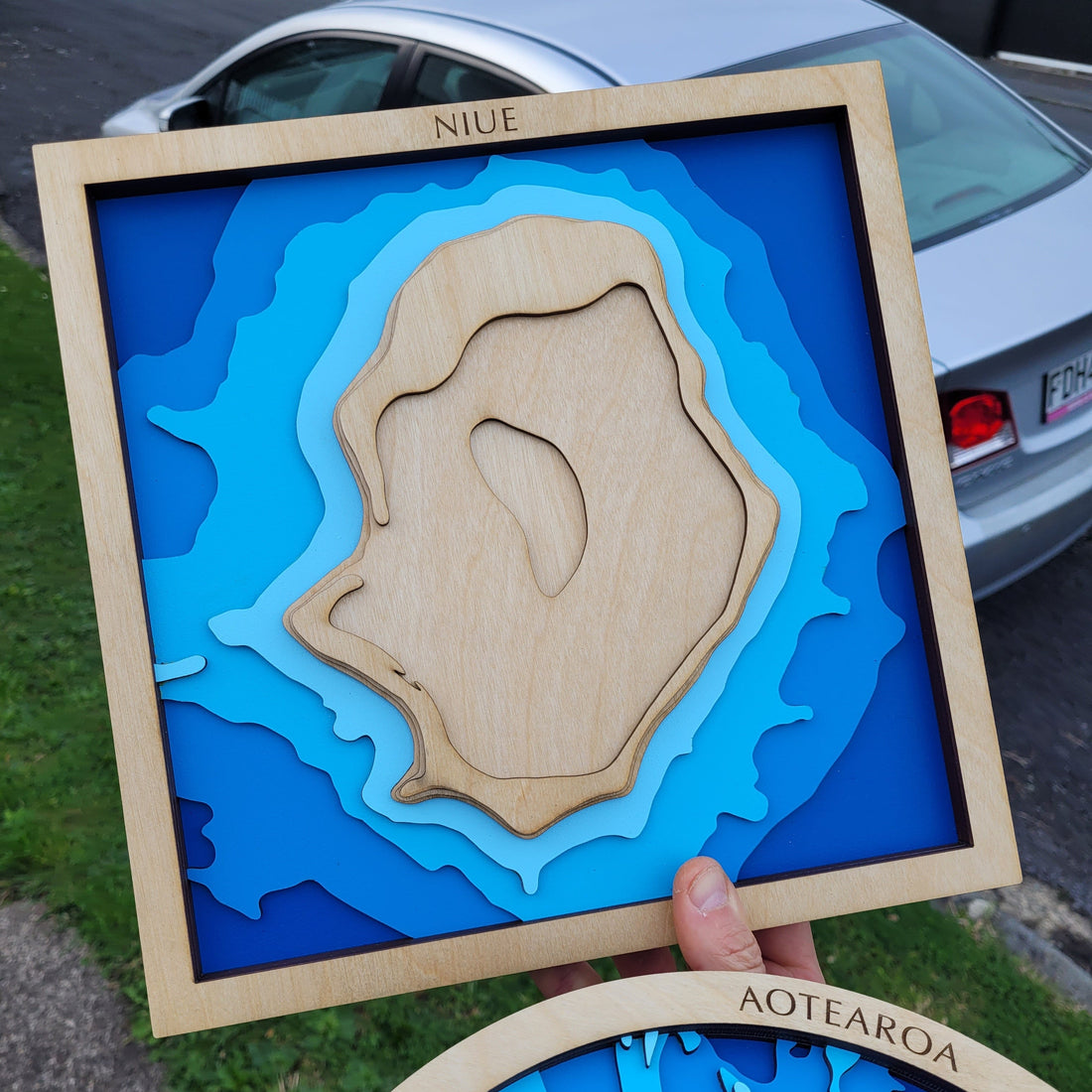
This is where our maps take on their tactile depth—not just visually, but physically. You can run your fingers along the seafloor, tracing bays, gulfs, and sounds with each contour.
📦 Many of our maps are made to order, including customisations like:
-
Family names
-
Location markers
-
Engraved messages or coordinates
🧵 3:00 PM – Personal Touches & Packaging
With the map complete, it’s time to wrap it up—literally. We:
-
Inspect every layer for quality and detail
-
Add any bespoke elements
-
Package each piece safely for delivery, using eco-conscious materials where possible
We often include a handwritten note—because we know these maps aren’t just décor. They’re gifts, memories, and personal stories.
🔁 4:00 PM – Back to the Board
Before wrapping the day, we return to the big map board on the wall and pin up our latest finished pieces. It’s a daily reminder of how local coastlines, deep-sea trenches, and personal places are brought to life through what we do.
🌐 Final Thoughts
Mapping the ocean floor isn’t just about depth data and design—it’s about capturing emotion, memory, and a connection to place. At Tides Out Maps, every map begins with the sea, but ends in the hands of someone who loves it.
Whether you’re a boatie, an ocean dreamer, or someone looking for the perfect gift, we hope you see the passion and process behind every map we make.