Every curve of the coast, every depth of the ocean — captured with precision and crafted with care. At Tides Out Maps, we transform New Zealand’s most iconic shorelines into timeless wall art that celebrates the beauty of our coastal waters. Here’s how we do it.
1. It All Begins with the Ocean Floor
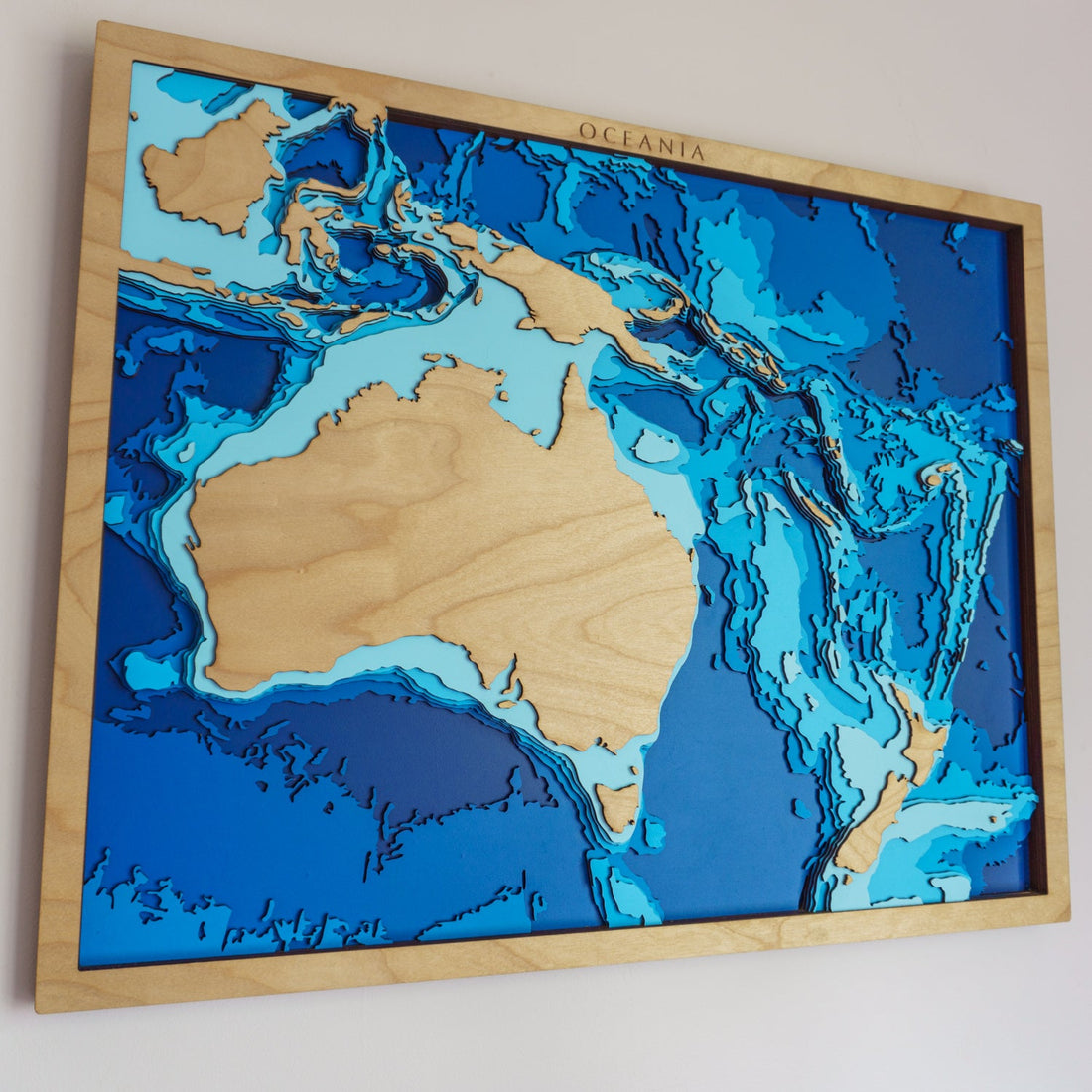
Our process starts with bathymetric data — the underwater equivalent of topographic maps. These data sets show the depths and contours of the seafloor around New Zealand’s coastlines. We use government and marine sources like LINZ (Land Information New Zealand) and international databases to gather this information.
We then clean, layer, and simplify the data to highlight the most visually striking and informative features, such as depth lines, sandbars, islands, and underwater slopes.
2. Choosing a Location with Heart
Whether it’s Waiheke Island, The Hauraki Gulf, or a quiet bay known only to locals, we select locations that mean something — to you, to us, and to Aotearoa.
Many of our map ideas are inspired by:
-
Beloved boating spots
-
Family holiday destinations
-
Fishing haunts
-
Scenic stretches with unique underwater geography
We also work on bespoke commissions, turning your favourite places into custom map art.
3. From Digital Map to Design File
Once we’ve chosen a region, we convert the bathymetric data into a layered digital design. Each depth level is given a distinct contour. Think of it like carving the sea — each layer reveals a deeper part of the ocean.
We add coastal landmarks, place names, and details that bring the location to life. Our maps are not just accurate — they’re artistic, designed to balance precision with visual flow.
4. Laser Cutting Each Layer of Wood
Next, our designs go from screen to timber. We laser-cut each depth layer from sustainable plywood sheets, capturing the details of the coastline and ocean floor.
-
Each map uses multiple stacked layers to show depth
-
Laser-cutting ensures exact precision for intricate coastlines
-
We sand, stain, and prepare each piece for final assembly
This process brings a tactile, sculptural quality to every map.
5. Assembling and Framing by Hand
Once cut, each map is assembled by hand in our NZ workshop. Layer by layer, the ocean takes shape. We glue, align, and frame every map, ensuring it’s ready to hang.
Depending on the size, maps can take several hours to complete — each one a unique, handcrafted piece of art.
We offer:
-
Four standard sizes (and custom if requested)
-
Vertical or horizontal layouts
-
Personalised messages, names, or location markers
6. Adding the Final Touch: Personalisation
We believe maps are more than just geography — they’re stories. That’s why we offer bespoke additions. Want to mark where you caught your first fish with Dad? Or the bay you got engaged? We can add:
-
A heart over a specific location
-
A name or date engraved on the map
-
Custom text on the back or frame
Our customers often say this is what makes the gift unforgettable.
7. From Coastline to Keepsake
What begins as ocean data becomes a piece of art — a coastal keepsake that holds memories, passions, and pride. Whether you’re buying for a boatie, a fisherman, a coastal homeowner, or just someone who loves New Zealand’s waters, our maps are made to tell a story.
Each one is:
-
100% NZ-made
-
Sustainable and built to last
-
A unique blend of data, design, and craftsmanship
Want to Create Your Own?
🌊 Start your bespoke map journey here →
Whether it’s a gift, a memory, or a piece of home — we’ll help you bring it to life.